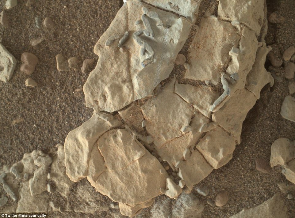
NASA’s Curiosity Mars rover has spotted a set of mysterious ‘stick-like figures’ on the red planet.
In a photo shared to the rover’s Twitter account this week, NASA revealed a look at the unusual formations recently discovered on the face of a Martian rock.
It’s unclear what exactly created the quarter-inch-long ‘stick-figures,’ though the space agency says they could be crystals or minerals left in the gaps where crystals dissolved.
The images were captured during the rover’s ‘working holiday’ at the end of December.
On New Year’s Eve, Curiosity revisited an ‘interesting’ site as part of its activity plan, to get a closer look what NASA says are some ‘very peculiar targets.’
Images captured from orbit with the Mars Reconnaissance Orbiter’s High Resolution Imaging Science Experiment camera reveal the region has some unusual blue hues.
And, it’s also home to a number of darker toned ‘stick’-like features.
‘Meanwhile, back on Mars…I’m checking out these stick-like figures,’ the Curiosity rover’s Twitter account tweeted on Wednesday.
‘Each is about a quarter-inch long. Maybe they’re crystals? Or they could be minerals that filled spaces where crystals dissolved away.
‘Stay tuned! Science continues.’
NASA’s ongoing Mars missions have revealed countless remarkable features on the surface of the red planet over the last few years.
An image captured recently by NASA’s Mars Reconnaissance Orbiter offered a stunning look at Mars’ northern Meridiani Planum, where swirling deposits appear as though they’ve been slashed by massive faults.
The amazing view shows the different effects of fault activity on the Martian surface, giving rise to everything from clean breaks to ‘stretched out’ distortions.
This is likely an indication that the faults formed at different times, when the layers were at various stages of hardening.
In a second image offering a closer look at some of the features, NASA has pointed out where the faults have displaced individual beds.
These areas, as noted by the yellow arrow, are where the faults produced a clean break.
In other regions, as noted by the green arrow, the layers appear stretched out as they span the fault.
‘These observations suggest that some of the faulting occurred while the layered deposits were still soft and could undergo deformation, whereas other faults formed later when the layers must have been solidified and produced a clean break,’ NASA explains.
Speckling the surface of one of Mars’ oldest impact basins, NASA’s Mars Reconnaissance Orbiter recently spotted a sprawling expanse of ‘honeycomb’ landforms, with individual cells of up to 6 miles wide.
The origin of these textured features has long remained a mystery, as scientists debate which type of natural process could be responsible, from glacial events to wind erosion.
It’s possible that multiple processes are at play, according to NASA, with evidence suggesting the honeycombs and the surrounding landscape in Mars northwestern Hellas Planitia may still be undergoing activity today.
MRO captured a look at the features with the Context camera and its HiRISE instrument, revealing greater detail.
Each cell is about 5-10 kilometers (3-6 miles), with rippling sand that suggests the region may have been subjected to wind erosion.
But, there may be other processes shaping the land as well.
Exposures of bedrock seen within the cells resemble features formed as dykes, NASA explains.
These are typically associated with volcanic activity.
According to NASA, ‘the lack of impact craters suggest that the landscape, along with these features, have been recently reshaped by a process, or number of processes that may even be active today.
‘Scientists have been debating how these honeycombed features are created, theorized from glacial events, lake formation, volcanic activity, and tectonic activity, to wind erosion.’
Recently, the Mars Reconnaissance Orbiter spotted a potential sand-producing region that could be feeding the red planet’s stunning expanse of dunes.
In a breathtaking new image, the space agency revealed a look at the sloping sediments near the boundary of Mars’ Southern highlands and Northern lowlands.
The image shows dark material is being eroded from layers of the bedrock in a massive surface depression, indicating the sand grains were not carried there by wind, according to NASA.
The image, captured by MRO’s Context Camera, shows linear markings in the huge depression that appear to slope downward.
This helps to tell the story of the processes taking place at the surface.
‘The grains of sand that make up sand dunes on Earth and Mars have a hazardous existence because of the way that they travel,’ NASA explained.
‘Wind-blown sand is lifted above the surface of each planet before crashing onto the ground and bouncing in a sequence of repeated hops, a process called saltation.
‘Sand grains can also roll along the ground as they are blown by the wind, and they are also jostled by other sand grains that are similarly flying across the surface.’


